
Project delivery in the construction and infrastructure industries involves a lot of collaboration between numerous players. One of the most important relationships is between the surveyors and BIM modelers. Surveyors add a unique perspective when it comes to creating accurate representations of spaces because they deal with the raw data that BIM modelers use to create precise and utilizable models. However, when these professionals work in congruence, then what is obtained is an integrated solution involving highly accurate measurements besides the incorporation of the latest modeling techniques for efficient design, construction, and maintenance. This blog post describes what surveyors and BIM modelers do, the challenges that arise when they work together; and how to make this synergy beneficial to deliver the best results on projects.

The Importance of Surveyors and BIM Modeler’s Collaboration
Surveys are very crucial in the planning phase of any construction project as they give appropriate site information such as ground features, property lines, and points of elevation. Whereas BIM modelers use this data to develop their electronic avatars of the built environment. By so doing it ensures that the results depicted in the digital models accurately simulate the existing conditions in the construction sites and hence facilitate proper decisions throughout the lifecycle of the project.
The Surveyor’s and BIM Modeler’s Collaboration is highly important in projects that involve a lot of space such as commercial building projects. If survey data can be fully incorporated into BIM, you can see the conditions of the site, assess potential obstacles, and organize work. This partnership not only helps to perform with fewer mistakes but also results in cutting back on the amount of time and material needed to rectify mistakes during construction.
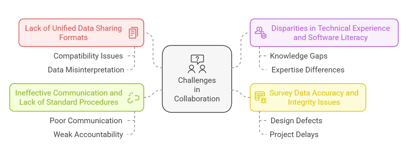
Challenges in Surveyors and BIM Modeler’s Collaboration
- Lack of Unified Data Sharing Formats:
Quite often, there is no clear format for data sharing, and this causes compatibility issues with specific viewers and wrong interpretation of the data displayed.
- Disparities in Technical Experience and Software Literacy:
Some of the common issues reported involve clashes in technical knowledge and the level of computer expertise of surveyors and BIM modelers.
- Survey Data Accuracy and Integrity Issues:
Inaccuracies or discrepancies captured in survey data while transmitting it into BIM models lead to design defects. Sometimes, such problems can be identified at a later project phase, which will lead to more serious consequences, including project delay and higher costs.
- Ineffective Communication and Lack of Standard Procedures:
The problem of lack of communication, and non-observance of standard practices worsen the collaboration problems and develop ineffective and weak accountability.
Optimising Surveyors and BIM Modelers Collaboration
However, Surveyors and BIM Modelers Collaboration should have a consistent plan for the project and their ways of working. Effective communication at the beginning of the survey prioritizes data regarding BIM compatibility to mean effective survey results are collected and in appropriate formats for input into BIM software. Another way to overcome barriers may be through more frequent meetings and the ability for surveyors and BIM modelers to work through workshops together in the field.
That is why laser scanning, drones, and GIS integration, as well as other modern technologies, strengthen surveyors’ and BIM modelers’ cooperation. These tools made it possible for surveyors to capture very accurate data that can be easily fed into the BIM model. When such technologies are applied, then it is easier to do the work and there is little chance of mistakes being made.
Another important factor also enhancing this relationship is training and professional development. Surveyors and BIM modelers must get to know what the other is doing and what tools they use. Additional training sessions related to collaboration between surveyors and BIM can help both sides use their strengths to achieve better results.
The Impact of Effective Collaboration
It can clearly be understood that when Surveyors and BIM Modelers Collaboration takes place, the advantages reaped are not limited to the core team of workers. High-quality BIM models that reflect actual data from surveys help in the proper planning and execution of a project and help provide clearer information to the stakeholders of the project. This alignment also enables seamless construction work to be conducted since physical construction models can be relied upon by the contractors.
However, the most important component that forms the basis of enhancing asset management is the combination of these two fields. Physical models derived from as-built survey data can be very useful in the maintenance and successful operation of the facilities throughout their useful life.
Conclusion
The Surveyors and BIM Modelers Collaboration attained the best results in the current construction project. Having the accuracy of survey data together with the intelligence of BIM modeling, teams can develop accurate models that enhance the value and effectiveness of a project. Standardization of processes, and technology and keeping a common channel of communication will help realize the full potential of this kind of partnership beyond the problems that may be encountered. Looking to the future as construction continues to embrace BIM Services, it will be essential that surveyors and BIM modelers work closely, hand in hand to deliver efficient, effective, and sustainable spaces for the future.
Leading BIM services provider. Adding Innovation and Excellence to the BIM Services.